By John Hamilton 12th Dec 2024
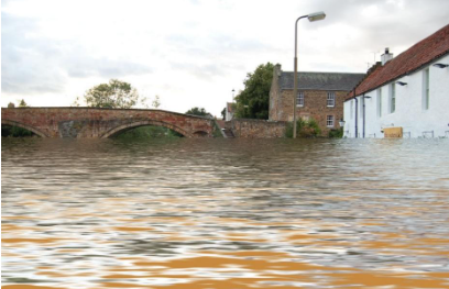
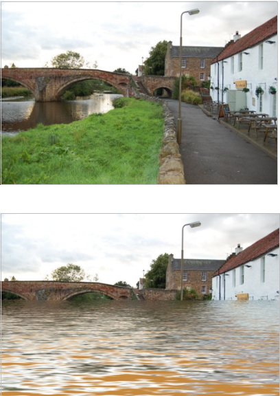
On 12-13 August 1948 the Tyne overflowed its banks, creating the worst flood in living memory. The Tyne has flooded parts of the town since but to a far more limited extent. John described how he and a surveyor friend set about producing photographs of the town in 2017 with the 1948 level of flood water superimposed upon them. This required research, accurate survey work and suitable computer software. Doubts about the accuracy of the flood level shown at Scamblers Corner led them to look for photographic evidence from the time. In particular a photograph of a man holding his hand at the high-water mark on the side of the old Peter Potter building in The Sands provided a reliable reference height. With the careful positioning of orange ping-pong balls as height markers, beginning with the reference, John and friend with a theodolite traced the water level at many points throughout the town. From this database John was able to superimpose water levels on modern photographs.
Historically, the flood reached the steps of the town house at the west end of the High Street and land and buildings closer to the Tyne were severely inundated. There are many photographs from the time archived in the John Gray Centre and elsewhere. 1948 seems such a long time ago but seeing this flood as it would have been in 2017, effectively now, perhaps brings home better to the 21st century eye the sheer magnitude of it. John talked us through paired photographs from around Haddington with and without floodwater so concluding a very interesting and entertaining presentation. With John’s permission I include here a pair of photographs as an example – showing the Nungate Bridge and the Waterside Bistro. The water level is just above the tops of the lower windows of the Bistro, and the walk-way tunnel under Bridge Street is completely submerged.
Summary by Peter Ramage
15/12/2024
You must be logged in to post a comment.